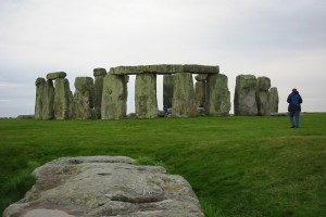
the other night we stumbled upon a NOVA episode exploring the logistics of constructing Stonehenge and how it connects to Durrington Walls up the River Avon. the heart of the portion we watched centered on one scholar’s theory about how the stones got to the famous site in the Salisbury Plain — placing the several-ton stones on platforms on tracks of milled timber with the equivalent of wood or stone ball bearings to allow the contraption to glide towards the destination. it was an interesting idea … for an age when modern milling and ball-bearings might be common, but I was inclined to agree with the criticism that it was perhaps a bit over-engineered for the Neolithic architects of Stonehenge. logs and lots of people with ropes seemed just as effective and perhaps more expeditious. but then, most of what we know about Stonehenge comes from educated guesses at best.
 the earthwork enclosure that encompasses the site dates from about 3100 BCE while radiocarbon testing and other evidence suggest the stones were erected sometime between 3000 and 2000 BCE, with the bluestones (the smaller ones) perhaps going up towards the beginning of that period and the remaining sarsens (the larger ones) later on. Stonehenge was constructed in several phases over a some 1,500 years, replacing monuments that previously stood on the site.
one of the more impressive facts about the site is the distance the stones traveled. while the precise origin remains unknown, it seems the bluestones came from the Preseli Hills in southwest Wales more than 150 miles away from Stonehenge (another theory posits they were glacial erratics left much closer to the site by the Irish Sea Glacier). in 2011, researchers at the University of Wales announced they’d identified the exact source from which the earliest stones were taken — 140 miles away in Pembrokshire in Wales. the sarsen stones are made of a type of sandstone found throughout southwest England but most archaeologists believe these stones came from the Marlborough Downs about 30 miles distant. as I mentioned, the bluestones were erected first, likely in a double-circle, and show signs of human efforts to shape them to fit together in some fashion. the sarsens were worked at the site using handmade tools; the NOVA program included excavation of some of the tools and stone shards carved off the sarsens.
the first signs of inhabitants on the site, however — four or five pits (some which held pine posts) — were discovered in the site’s parking lot between the 1960s and 80s and date to sometime between 8500 and 7000 BCE (the Mesolithic era!). recently uncovered evidence suggests the site may have been used for burials from the beginning, with cremains found in and around pits along the bank and ditch; in the 64 identified burial sites archaeologists have found remains for as many as 150 individuals. the NOVA program also chronicled excavations along the banks of the River Avon by archaeologists, seeking to determine whether the avenue did, in fact, continue all the way to the river and thus, presumably, symbolically and physically connect Stonehenge with Durrington Walls up the river. based on the positioning of the two sites, the researchers proposed Durrington Walls as a “site of the living” (as it aligned with sunrise) while Stonehenge was a “site of the dead” (as it aligned with the sunset and was a site for burial).
beginning in the 1920s, the National Trust began purchasing land around Stonehenge to preserve the setting around the monument as early in the 20th century land nearby was increasingly turned to cultivation. since the 1980s, the National Trust has worked with local landowners to revert some of this previous farmland back to chalk grassland. the setting-preservation effort was undermined somewhat by the two roadways — the A344 and the A303. over the last several decades plans have repeatedly been advanced then shelved to close or reroute the two roads in order to return the atmosphere of the site to how it might have been millennia ago. in 2010, the Wiltshire Council approved plans for a new visitors center to replace the one built in the 1970s, but forward progress is currently held up by getting acquiescence to close the A344 and two other nearby roadways.
of course, the sheer volume of visitors will still affect how one experiences Stonehenge. at the turn of the 20th century, concern for visitor safety (coupled with the toppling of an outer sarsen and its lintel) prompted the then-owner to begin the process of re-erecting fallen stones and stabilising the bases of others. the site was donated to the nation in 1918 by Cecil Chubb (who’d purchased several years earlier in an auction) who became responsible for its upkeep and providing access. between 1938 and today, annual visitors to the site increased from 38,000 to over 900,000. in 1978, erosion of the earthworks due to the increased number of visitors and acts of vandalism to the stones resulted in access to the stones being restricted. today, visitors are only allowed to tour Stonehenge from roped-off paths that prevent too many people from accessing the stones at any given period.
even though access to the stones is restricted, it isn’t prohibited; it just requires some planning, forethought, and approval from the National Trust. my dad was one with such foresight and managed to coordinate an early-Sunday-morning visit for us when my parents came to visit me while I was studying in London. it’s a truly unique experience to get such remarkable access to a monument so impressive, so old, and so shrouded in mystery. the first time I visited England, we focused more time on Avebury and (if I recall correctly) just stopped along the road and looked through the fence at Stonehenge, rather than paying the entrance fee to walk around the roped-off path. it was worth the wait, though, to get to to stand so close the stones, to touch them and walk among them. if you’re ever in the vicinity, I highly recommend taking the time to visit and, if you’ve got some foresight, too, plan ahead for one of those outside-operating-hours access spots.
some final thoughts:
if you’re in Ireland, you should definitely make the effort to visit Brú na Bóinne (it’s on the itinerary for the next trip to Ireland this summer!) another remarkable Neolithic site.
check out the NOVA program, Secrets of Stonehenge, for more on all the projects I referenced above.
lastly, one of my favorite travel blogs, Twenty-Something Travel, posts “Friday Postcards” and the one from this week was, coincidentally, Stonehenge at sunrise!


