Congress Avenue Bats

each year when my friends and I get together, we try to do quirky things in the city we visit, in addition to more traditionally touristy stuff. I’m not sure where on the spectrum visiting the Congress Avenue bat colony falls … quirky for sure, but also very popular! the colony consists of between 750,000 and a million and a half Mexican free-tailed bats; they summer in Austin and migrate to Mexico for the winter. Sunset OverLady Bird Lake

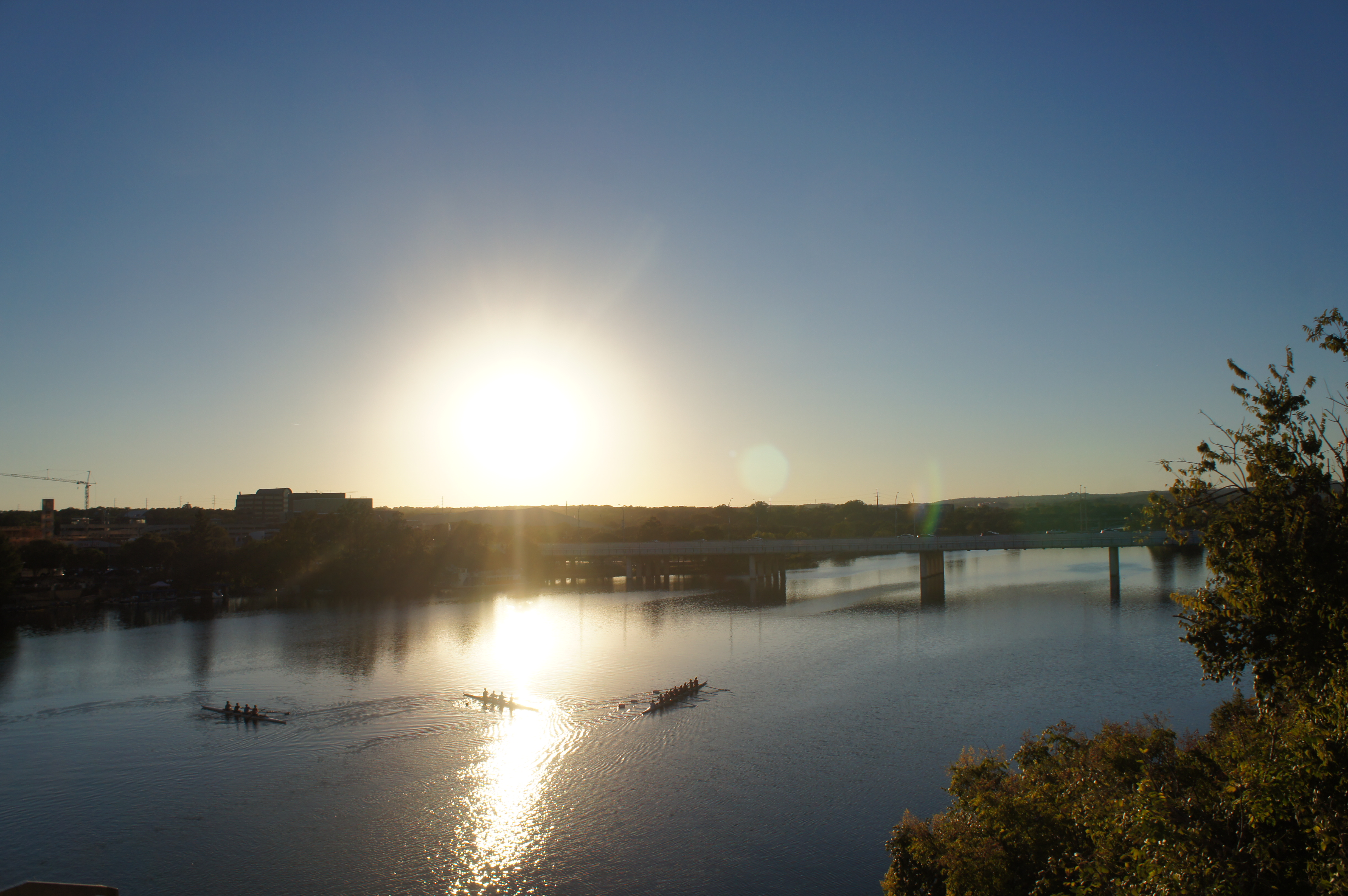
for all appearances, the bridge doesn’t seem terribly special; three lanes in each direction over Lady Bird Lake in a spot that has hosted a bridge since the early 1870s (a pontoon toll bridge). the City of Austin assumed complete responsibility over the (newer, iron) bridge in the late 1880s, which they were forced to repair several times over the subsequent two decades. by 1908, increase in traffic demanded the construction of a newer, wider bridge and a proposal for the current concrete span bridge were drawn up. at 910 feet it includes six spans which rise to 45 feet above ground; it opened on April 4, 1910.

Waiting for bats

the bats came to live under the bridge following refurbishment that occurred in 1980. there are fifteen crevices beneath the roadbed, each about 17 inches deep, which appealed to the bats and offered about 14,000 feet of potential habitat. the bats emerge from their roosts each dusk to search for food, swarming out towards the east for 10 or 20 minutes. tourists congregate on the bridge’s sidewalks, in the parking lot of the Austin-American Statesman, and on boats in Lady Bird Lake. we opted to stand on the sidewalk (near a family with two young boys calling out to the bats “hey, bats, come out so we can see you!”), but saw a fair few people out on water bikes, kayaks, stand-up paddleboards, paddle boats, canoes, and one paddling swan. we ended up waiting about an hour before the bats emerged, but in the interim the sunset off to the west provided a remarkable diversion .

Audubon Park

Audubon Park, once a plantation, was used by both the Union and Confederate Armies during the Civil War, as well as staging ground for the Buffalo Soldiers following the war. named for the famed naturalist, the city purchased the park in 1870 with the intention of creating a park. little development of the park occurred in the first decade the city owned it, but it managed to host the World Cotton Centennial (a World’s Fair) in 1884. development began in earnest thereafter though nearly all of the Fair buildings came down in favor of others. structures went up and down throughout the 20th century – a miniature railway, swan boats, carousel, a viewing shelter on the banks of the Mississippi, a conservatory. several early features remain – a golf course from 1898 (converted to Par 3 executive course in 2002 and protested as desecrating the original design of the park), the zoo (which received development aid from the Works Progress Administration), and a rookery on Oschner Island, which hosts a wide array of birds (including herons, egrets, and cormorants) and apparently makes for some of the best birding in New Orleans.

during Katrina, a few of the park’s oak trees blew over, but the park escaped flooding and attendant problems because of its location on top of the River’s natural levee. following the storm, it served as a makeshift helicopter port and encampment for National Guard troops and relief workers.

we made use of Audubon Park for a morning run – once we finally got there, after walking from the end of the (construction-shortened) streetcar line. we had to share the 1.7 mile paved path (which was closed to vehicles in the 1980s) with a swarm of parents and children engaged in a charity run/walk of some kind. the costumes on some of the kids – and the gravel path to one side – mostly made up for the congestion. next time, I wager we’d try the longer dirt path that skirts the edge of the park!

Stone Academy

the Stone Academy sits on the side of the road north of Iowa City on the way to Dubuque – easy to miss but by far the most interesting roadside historic mark on that stretch of road. (all the others are just signs – a physical structure always beats just signs.) that route, highway 1, was the stagecoach route between burgeoning Iowa City and Dubuque, as well as part of the longer Montreal-Mexico trail. plenty of westward-moving settlers enjoyed putting down roots near a well-traveled road. at the time, Native Americans had not yet been shunted out of eastern Iowa and still lived in camps along the stagecoach route and within site of the school building. built in 1842, before Iowa became a state, the school remained in operation until 1953. the stones for the building were quarried on the east bank of the Cedar River, ferried, and hauled two miles to construct the schoolhouse. students attending the school came from nearby farms and homesteads and varied widely in age; some young men, otherwise considered “too old” for school, would attend during the winter as it provided a diversion between harvest and planting. today, it’s shuttered but maintained, well off main routes of travel – unless you’re going from Dubuque to Iowa City.

Piedras Blancas Lighthouse

several miles north of San Simeon stands the Piedras Blancas Lighthouse. construction of the lighthouse began in mid-1874 and the first-order Fresnel lens was first lit in February 1875. the U.S. Lighthouse Service oversaw operations until 1939, when it was transferred to the U.S. Coast Guard. the tower originally stood 100 feet tall but a series of earthquakes damaged it and, following one in 1948 centered just 6 miles away, the top three floors were removed – including the watchroom and lantern. the original lens now sits on display in Cambria.

from 1906, the station also used a sound signal to alert passing vessels of danger. the sound alert was removed in 1975 when the station was automated; the Coast Guard continued to operate it until 2001 at which time it was handed over to the Bureau of Land Management to allow “structured public access.” the light continues to operate, but the land now serves as a natural sanctuary and  research station, offering tours of the light station and wildlife refuge throughout the week. the largest colony of elephant seals on the west coast makes their home on a beach about a mile south of Piedras Blancas.

there are plans to move several miles of Highway 1 near Piedras Blancas farther inland in anticipation of rising sea levels. there are portions of the highway jsut north of the lighthouse that are only protected from the ocean by an artificial embankment and cement traffic barriers, which high swells periodically over-top, causing traffic hazards.

California’s Highway 1

SONY DSC

one thing I’ve wanted to do since I first lived in California was to drive along Highway 1. the few times I drove up to the Bay area while living in San Diego, though, I had time constraints and no one to enjoy the drive with me. in hindsight, I’m glad I waited because we had a great time driving back from Monterey along Highway 1 as part of our mini-moon. neither the drive nor the weather disappointed as we set off early on a late-August morning.

the highway, which runs along the coast from Orange to Mendecino County was constructed in segments starting in 1910 and sported many names over the last century, until a legislative act designated it all California State Route 1. between 1915 and 1964, all the different segments had numerical designations, but only highway planners and legislators ever referred to those numbers; designations never appeared along the roads themselves.

the stretch between Carmel (just south of Monterey) and San Simeon (site of newspaper magnate William Randoph Hearst’s famous castle) received initial state funding in 1919, followed by some federal funding in 1921 and support from the New Deal later. much of the highway went up because of the labor of convicts. the San Quentin State Prison set up three camps along the route, paid inmates $0.35 a day and offered reductions in sentences in exchange for their unskilled labor.

View of Coastal Hwy 1

the stretch of highway we drove required the construction of 33 concrete bridges, including the iconic Bixby Creek Bridge near Big Sur. prior to the completion of the bridge, residents of Big Sur often endured months of isolation in winter; the single-lane stagecoach Old Coast Road, which connected the community to the inland, became impassable with rain and the rugged coastline made deliveries from Monterey or San Francsico by boat difficult. the bridge (and creek) are named after a gent who moved to the Monterey Peninsula in 1868 and purchased a large tract of land near Big Sur to harvest lumber and produce and distribute other wood products from his sawmill. the bridge was designed by F.W. Panhorst who, along with highway engineer C.H. Purcell, opted for a cement span for its lower material and maintenance costs (a steel span! that close to the ocean! what kind of fool would do that?!) and for its more natural aesthetic. it took 14 months to construct and, upon completion, was the longest concrete arch span bridge in the California highway system. the bridge itself is 714 feet long, the main arch is 320 feet long, and over 280 feet high. extensive seismic retrofitting occurred in the late 1990s but even after the updates, the bridge remains classified as “functionally obsolete” because it is less than 32 feet wide, as required with newly-built bridges.

the route finally got consistent numbering in 1964 thanks to legislative action, though different segments of highway have different names (Pacific Coast, Cabrillo, and Shoreline) going up the coast and local roads often weren’t changed to align with the numbering. the entirety of route 1 is a Blue Star Memorial Highway, honoring armed forces and the section between Big Sur and Carmel is a national scenic byway, declared in 1965 and dedicated in 1966 by Lady Bird Johnson from the Bixby Creek Bridge. and all around well worth the drive time!