León — kingdom and province

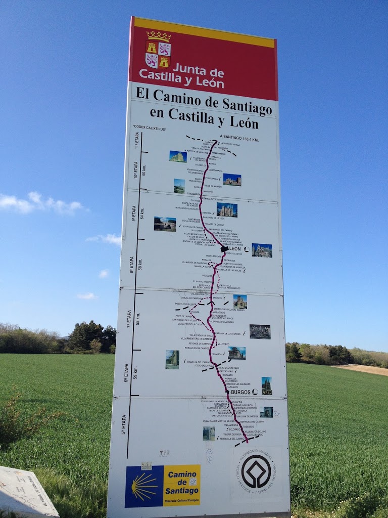
shortly after leaving Terradillos we crossed into the largest region along the Camino — León — with a population of more than 2.5 million and an area of 6,000 square miles. an independent kingdom for nearly 300 years, the fortunes of León later waxed and waned, tied as they were to the fortunes of Castilla. fraternal conflicts plagued the region for generations, following the division of Alfonso the Great’s territories among his three sons, as did tensions between Christian forces to the north and Muslims to the south.

Ramiro II (who ruled 931-951) brought stability and behind his military advances into land once held by the Moors came a process of repoblación that sought to repopulate the meseta alta with people from Galicia, which brought rise to a distinct dialect as well as unique form of artistic expression in Mozarabic art.  by the end of the 10th century the Kingdom of León had expanded to include the city of Burgos, which it fortified with the many castles for which the far reaches of the region later became known.

when the territories initially merged, León had the upper hand over Castilla; an assortment of military campaigns (mostly associated with the Reconquest) took their tolls on the joint future of the kingdom and in 1157 they split again when a defeat of Alfonso VIII weakened the authority of Castilla. only a few years later, Alfonso IX feared his death would bring the downfall of the Leonese kingdom due to lack of a suitable heir and designated as successors the daughters of his first wife. this proved unsuccessful and his son by another mother, Ferdinand III of Castilla, invaded León after his death (in 1230), assumed the throne, and became the first in a long line of joint sovereigns. perhaps not unlike the “union” of British and Scottish thrones, the “union” of Castilla and León did not go over well with the Leonese and it took Ferdinand III two full years to adequately quash uprisings that opposed his right to the throne. gradually, Castillian influence usurped that of León and though the throne continued to acknowledge the León title by acknowledging it first and using the lion on its crest, power grew more concentrated in Castilla. throughout the centuries, attempts at thwarting or throwing off Castillian influence have tried and failed; without Castilla, León and two other regions declared war against Napoleon’s France in the 19th century and anti-Castillian political parties remain popular to this day and the most die-hard activists persist in defacing governmental signs that acknowledge the autonomous region of Castilla y León that exists today.

entering Castilla

on day 10 we crossed into the third — and largest — autonomous region on our Camino: Castilla y León. encompassing over 94,000 square kilometers and (in 2011) home to 2.5 million people, it is the largest region in Spain. because the governments are autonomous, each offers slightly different aides for peregrinos — maps, directional markers, municipal albergues. the maps in Castilla y León were perhaps the most useful and comprehensive, though found less frequently than in Galicia, for example. as you can see, it includes all the tiny towns along the Camino, as well as noteworthy sights, plus distances listed by the stages of the medieval method of Camino demarcation — the Codex Calixtinus (about which more soon).


the climate and geography Castilla y León differ quite dramatically from the preceding and subsequent regions and, thinking back, I’m rather surprised at how quickly the change occurred. whereas rolling hills characterize Rioja and Navarra, the terrain of Castilla y León primarily consists of and largely constitutes Spain’s Meseta Central, an arid, mostly flat, high plain with elevations between 610 and 760 meters. basically, it was very flat with the occasional steep mesa or small hill. mountain ranges border and divide Castilla y León into smaller regions; thankfully, for the most part we got to enjoy the mountain views from afar rather than while climbing over ranges. because its buffered on all sides by mountain ranges, the region remains quite arid though, because of its size, temperatures and precipitation vary dramatically. in the central areas, fewer than 18 inches of rain might fall a year while to the west upwards of 59 inches might fall.


as one might deduce, the roots of Castilla y León lie in separate kingdoms of the middle ages. the name of the former comes from the castles and forts built to defend the kingdom’s eastern border (similar to those discussed in previous posts) and was first referenced in 800. over the next century and a half the kingdom was periodically divided and reconstituted until, through the rebellion efforts of Count Fernán González , the kingdom was unified into an autonomous entity in 931 that no longer paid vassalage to León. 

this independence was short lived as a series of political machinations-via-marriage, untimely deaths, and brotherly feuds brought the two kingdoms under the same crown for a brief period during the reign of Ferdinand I. his death in 1065 resulted in division of territories among sons, fighting between said sons, more reunification, more divisions, more fighting, and so on into the 13th century. Alfonso VII divided the territory between his two sons (Sancho III got Castilla; Ferdinand II, León). the two factions finally joined permanently when in 1230, after having assumed the throne of Castilla in 1217 through his mother, Ferdinand III assumed the throne of León through his father Alfonso IX.
 
León was formed when Alfonso the Great (III of Asturias) divided his land among his three sons, with Galicia, León and Asturias going to Ordoño II, García I, and Fruela II, respectively. Ordoño II’s successor, Ramiro II worked ardently to push back Muslim incursions, successfully driving them back from previously-settled territory and establishing a no-go area along the Duoro river valley that divided northern Christian-held territory from Muslim-held territory on the southern Iberian peninsula.

despite Alfonso IX best intentions, the unification of Castilla and León under one crown remains a contentious issue. the people of León did not take the increasing dominance Castilla well and, even today, we saw lots of anti-Castillian sentiment in the western part of the region. (throughout Astorga, for example, someone had gone around town and spray-painted out the “Castilla” part on governmental signs.) despite the royal centralization, the regions retained separate languages, currencies, flags, laws, and governmental systems until Spain centralized its government in the modern era, though by the 16th century Castilla had assumed majority control and León was, in practice, a captaincy-general. (fun fact: in 19th century, the Kingdom of León joined Galicia and Asturias to declare war on France — presumably against Napoleon.)

and all of this is to say that Castilla y León is big. the biggest region we walked through by a long way and despite the unity one might infer by the name, reality is somewhat different. researching all this has put that portion of the Camino into a different perspective for me — at the time it seemed dully monotonous because the terrain remained relatively static; but it turns out there’s a rich socio-political history to uncover. just took a little digging.

Santo Domingo de la Calzada

the popular town of Santo Domingo de la Calzada takes its name from Domingo García, an 11th century hermit who improved conditions on the Camino for peregrinos. he repeatedly tried to join the Benedictines, spending time studying at two different monasteries, but he proved so inept in his studies they refused to let him continue. still determined to live a religious life, he became a hermit and, following a dream, went to work with San Gregorio Ostiense (who’d been sent by papal envoy to to address a locust plague affecting Navarra and Rioja) improving the Camino in Rioja. when Gregorio died, Domingo returned to the region of the rio Oja (where he’d been a hermit) to continue their work.

his first project was building a stone causeway (calzada), leading to the wooden bridge he’d helped Gregorio construct. it served served as an alternative to the Roman route between Burgos and Leon. that done, he used a sickle to cut 37 kilometers of road through forests to improve the route between Nájera and Redecilla del Camino (on the way to Belorado). as this route became more popular, he replaced the wooden bridge with one of stone. soon thereafter, García Sánchez III granted Domingo permission to convert an old fort into un hospital de peregrinos; around this hospice a larger village grew.

peregrino statue/fountain

when King Alfonso VI of Castilla captured the area in 1076, he enlisted Domingo’s help in civic works projects like those he’d already undertaken. (Alfonso VI was the first to officially refer to the region as “La Rioja” after the river that is the region’s focal point. I felt silly for not noting this fact earlier.) together with a disciple (San Juan de Ortega), Domingo devoted the remainder of his live to improving the Camino — rebuilding bridges, clearing more roadway, anything that bolstered his vision. he devoted his last few years to constructing a church in the village, where he was buried upon his death in 1109. though his church burned in the mid-12th century, the replacement (a colegiata) was much larger and sufficiently impressive to warrant the transfer of the bishopric from Calahorra there in 1227.

as with all saints, miracles are attributed to Santo Domingo de la Calzada, about which you can read more here. suffice it to say that, in honor of Domingo’s miracles, a rooster and a chicken (with white feathers) are kept on the cathedral grounds and peregrinos used to gather feathers from the birds and affix them to their hats. it was said that if one of the chickens ate directly from the hand of a particular peregrino it meant he (or she) would make it to Santiago de Compostela safely.

again, the village location on the Navarra-Castilla frontier meant it changed hands more often than residents enjoyed — six times between 1076 and 1143 (with Castilla ultimately victorious). two centuries later it was also the focal point of Pedro the Cruel’s ill-fated war against his brother; leading up to 1364, Pedro had 38 towers and 7 gates built along a 1.6 kilometer wall that enclosed the city. those walls remained largely intact until 1886; today only the fragments of 8 towers, 2 gates, and 300 meters of wall remain.

unlike many of the other small towns that we passed through on our way to Santo Domingo de la Calzada, this town has grown fairly steadily since the 1850s. as of 2010 the population stands at just under 7,000 inhabitants.

Nájera

a day of welcome overcast skies brought us to Nájera, a town astride the rio Najerilla at the base of some remarkable cliffs. again — Roman origins, Moorish control for a while (the name of the town actually has Arabic origins), but a history of more diplomatic rather than military transitions of power. by virtue of its location, Nájera controlled both the east-west traffic on the Camino, but also the transport of goods downriver from the fertile plains nearby. 


Nájera was a multicultural city from early on and part of the first translation of the Qur’an into a European language may have originated here. much of Spanish law derives from the charter granted the town by Sancho Garces III, who also minted the first Christian coinage in Spain following the expulsion of the Moors.  as with many other towns along the Camino, Nájera hosted a sizable Jewish population but unlike persecution endured elsewhere, the 11th-century charter equalized penalty for killing a noble, a cleric, or a Jew at 250 sueldos.


there was a spot of bother with the Monasterio de Santa Maria stemming from the Castillian capture of Rioja in 1076. a Castillian king donated the monastery to the Benedictines of Cluny in 1079, which enraged the bishop of the monastery, who physically relocated the bishopric to Calahorra, downriver. when later appealed to for intervention, the Pope declined and the new bishop took matters into his own hands, raiding the monastery, assaulting monks, and stealing valuables from the altars and library. the Pope did not take to kindly to this, excommunicating the bishop, who was also barred from entering Navarra by its king. shortly thereafter Castilla and Navarra went to war over Rioja and the new prior of the monastery managed to enrich it by playing both sides. 

interesting fact for Anglophiles: Edward the Black Prince led troops at the Battle of Nájera in 1367, supporting Pedro (the Cruel) against his brother Enrique II in the Castillian Civil War (also part of the Hundred Years War). the English-backed Pedro completely routed the French-backed Enrique — the English were attacking dismounted French troops and were using longbows for the first time in the Iberian Peninsula. despite Pedro’s victory here, however, he didn’t hold onto power for very long; he and Edward fell out over money and he couldn’t sustain his throne without the benefit of foreign support.