LBJ Presidential Library

one consequence of traveling with college friends who also studied political science is that when one visits a city with a Presidential Library, that Presidential Library comes up as a tour prospect. it also means you have much greater, more interesting context for the LBJ presidential years than what the library presents to you, which is a little exhilarating.LBJ Archive

the library and museum are administered by the   National Archives and include more than 45 million items, primarily from LBJ but also from close associates. the Library, situated adjacent to the LBJ School of Public Affairs on the University of Texas – Austin campus, was dedicated in 1971 with Johnson and Nixon in attendance. the core of the building is a remarkable four-story, glass-encased view of the archive’s holdings. quite a different presentation than the one I got to see first hand in the Wisconsin Historical Society archives – impressively illuminated and with each archival box featuring the Presidential Seal.LBJ's Oval Office

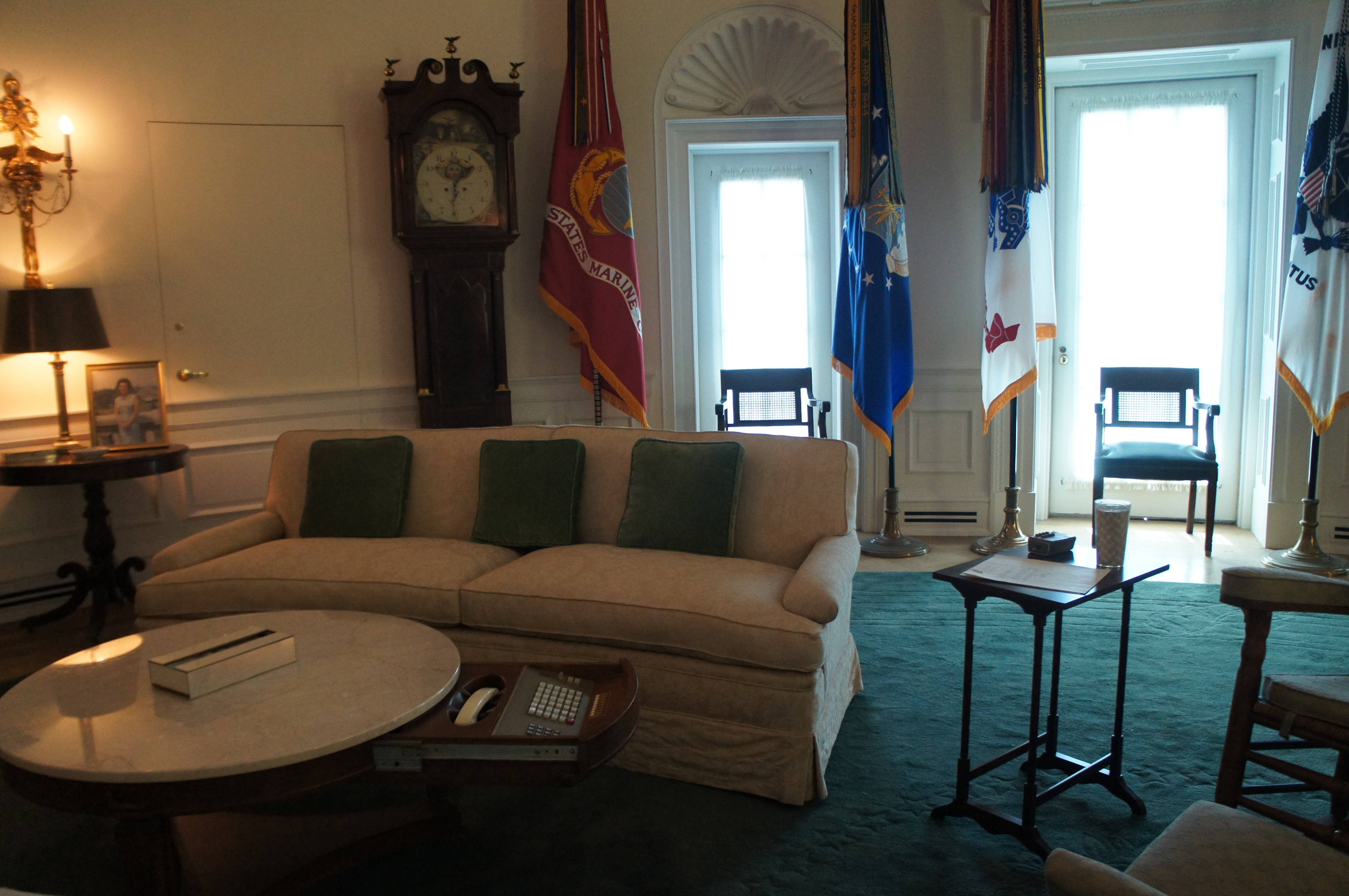
the top floor features is a 7/8th replica of the Oval Office as it appeared during Johnson’s presidency, including a cabinet with enough televisions installed to show all major networks simultaneously (you know, the 4 or 5 of them). in the corner of the building of that same floor, overlooking the football stadium, is Lady Bird Johnson’s office, preserved as she used it until her death in 2007.

Lady Bird's Office

Buford Tower

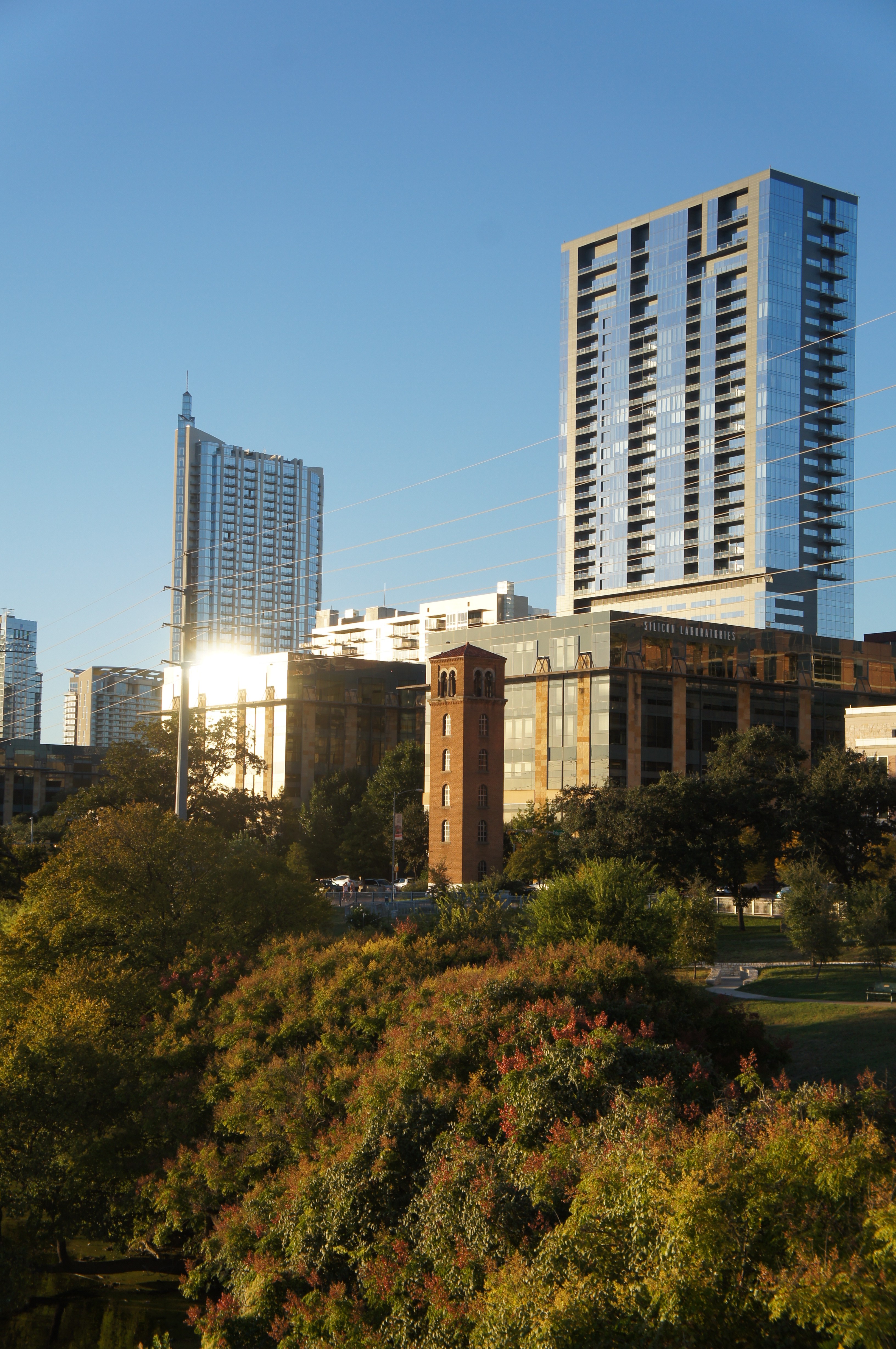
sucker that I am for buildings with interesting historical backgrounds, one of the sites I found most interesting on our amphibious tour of Austin was the Buford Tower on West Chavez Street. our driver, an admitted former firefighter, pointed out the building in passing – something the force used previously for training purposes – but I was curious to learn more.

Buford Tower
Buford Tower against Austin skyline

built in 1930, it was used for practice for nearly five decades before being replaced by another structure elsewhere in town. it stood disused for several years until the widow of the man  who designed the tower donated money to have it refurbished and to have the upper floors converted for use as a carillon tower. it’s name honors James Buford, a captain who drowned attempting to rescue a 15-year-old from flood waters in Shoal Creek. now, it’s an interesting, incongruous site against the modern structures of downtown Austin.

Congress Avenue Bats

each year when my friends and I get together, we try to do quirky things in the city we visit, in addition to more traditionally touristy stuff. I’m not sure where on the spectrum visiting the Congress Avenue bat colony falls … quirky for sure, but also very popular! the colony consists of between 750,000 and a million and a half Mexican free-tailed bats; they summer in Austin and migrate to Mexico for the winter. Sunset OverLady Bird Lake

for all appearances, the bridge doesn’t seem terribly special; three lanes in each direction over Lady Bird Lake in a spot that has hosted a bridge since the early 1870s (a pontoon toll bridge). the City of Austin assumed complete responsibility over the (newer, iron) bridge in the late 1880s, which they were forced to repair several times over the subsequent two decades. by 1908, increase in traffic demanded the construction of a newer, wider bridge and a proposal for the current concrete span bridge were drawn up. at 910 feet it includes six spans which rise to 45 feet above ground; it opened on April 4, 1910.

Waiting for bats

the bats came to live under the bridge following refurbishment that occurred in 1980. there are fifteen crevices beneath the roadbed, each about 17 inches deep, which appealed to the bats and offered about 14,000 feet of potential habitat. the bats emerge from their roosts each dusk to search for food, swarming out towards the east for 10 or 20 minutes. tourists congregate on the bridge’s sidewalks, in the parking lot of the Austin-American Statesman, and on boats in Lady Bird Lake. we opted to stand on the sidewalk (near a family with two young boys calling out to the bats “hey, bats, come out so we can see you!”), but saw a fair few people out on water bikes, kayaks, stand-up paddleboards, paddle boats, canoes, and one paddling swan. we ended up waiting about an hour before the bats emerged, but in the interim the sunset off to the west provided a remarkable diversion .

Audubon Park

Audubon Park, once a plantation, was used by both the Union and Confederate Armies during the Civil War, as well as staging ground for the Buffalo Soldiers following the war. named for the famed naturalist, the city purchased the park in 1870 with the intention of creating a park. little development of the park occurred in the first decade the city owned it, but it managed to host the World Cotton Centennial (a World’s Fair) in 1884. development began in earnest thereafter though nearly all of the Fair buildings came down in favor of others. structures went up and down throughout the 20th century – a miniature railway, swan boats, carousel, a viewing shelter on the banks of the Mississippi, a conservatory. several early features remain – a golf course from 1898 (converted to Par 3 executive course in 2002 and protested as desecrating the original design of the park), the zoo (which received development aid from the Works Progress Administration), and a rookery on Oschner Island, which hosts a wide array of birds (including herons, egrets, and cormorants) and apparently makes for some of the best birding in New Orleans.

during Katrina, a few of the park’s oak trees blew over, but the park escaped flooding and attendant problems because of its location on top of the River’s natural levee. following the storm, it served as a makeshift helicopter port and encampment for National Guard troops and relief workers.

we made use of Audubon Park for a morning run – once we finally got there, after walking from the end of the (construction-shortened) streetcar line. we had to share the 1.7 mile paved path (which was closed to vehicles in the 1980s) with a swarm of parents and children engaged in a charity run/walk of some kind. the costumes on some of the kids – and the gravel path to one side – mostly made up for the congestion. next time, I wager we’d try the longer dirt path that skirts the edge of the park!

Plessy in New Orleans

the American history courses I took in high school differed from others in the emphasis placed on the experience of blacks and other people of color (the section covering the 20th century that I opted for was titled “African American Experience,” whereas the option most of school took was titled “American Experience”). however, while we spent quite a bit of time discussing various pieces of landmark legislation pertaining to social justice and racial equality, I was surprised to (re)discover Plessy’s link to New Orleans while exploring the exhibits of the Cabildo.

Homer Plessy was born to French-speaking Creole parents just before the outbreak of the Civil War and just after General Benjamin Butler’s troops occupied the city and liberated enslaved African Americans. his paternal grandfather, a white Frenchman from Bordeaux, arrived in New Orleans after leaving Haiti in the wake the rebellion that liberated the nation from Napoleon’s France. after his father’s death in 1869, his mother married a clerk at the U.S. Post Office who supplemented his income as a shoemaker. Plessy followed his stepfather into the shoe business, and also worked as a clerk and insurance agent, according to city records.

during the period of occupation and Reconstruction in which Plessy grew up, blacks in the city enjoyed a degree of freedom unheard of in the rest of the South – marrying freely and attending integrated schools (briefly), among other rights. in 1873, his stepfather signed on to the Unification Movement which sought to establish equality in Louisiana (which had a more laissez-faire attitude about racial segregation from its early years as something of a remote backwater up until it became a state and its liberality conflicted with laws of neighboring states.) once federal troops withdrew from the city by the order of President Hayes in 1877, however, rights hitherto enjoyed by most and any prospect for a racially egalitarian society vanished.

from a young age, Plessy displayed political and social conscious; he served as a leader in an education reform movement and, ultimately, joined a mixed-race civil rights group called the Comite de Cityones. not unlike the Montgomery Improvement Association, the Comite orchestrated the events that culminated in the landmark Plessy v. Ferguson case. as with the Montgomery boycott some six decades later, Plessy’s appearance contributed to the plan — as one scholar noted, he was white enough to gain access to the location where he was black enough to get arrested. on June 7, 1892, he bought a first-class ticket on train between New Orleans and Covington and took a seat in the “whites-only” car. when asked for his ticket Plessy stated that, as a person 7/8 white, he did not want to sit in the “blacks-only” car. he was arrested immediately, held overnight on $500 bond and tried a month later for the offense.

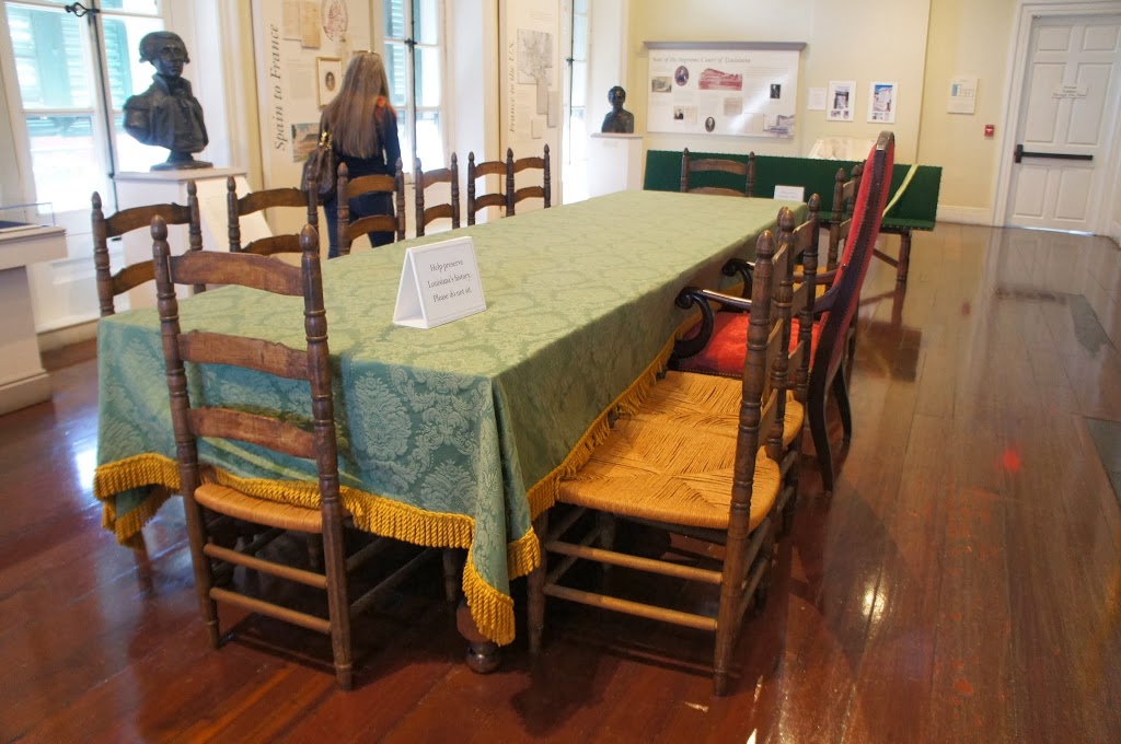
the trial – before Judge John Howard Ferguson – took place in one of the second floor rooms of the Cabildo and Plessy’s case rested on the argument that the law that resulted in his arrest violated his rights under the recently-passed Thirteenth and Fourteenth Amendments. Ferguson disagreed based on the contention that the state could set rules for railroad business that took place within its borders. the State Supreme Court upheld Ferguson’s ruling and refused to rehear the case but allowed for a petition for writ of error, which allowed the case to progress to the United States Supreme Court.

in 1896, the U.S. Supreme Court heard and ruled on the case, the majority opinion laying out the doctrine of “separate but equal” that permitted states to segregate with federal permission until struck down by the Brown v. Board decision of 1954. (one Justice – John Marshall Harlan of Kentucky – dissented on the grounds that the Louisiana law was inconsistent with the liberty citizens and was hostile to both the spirit and letter of the U.S. Constitution. his position on this and other cases dealing with racial segregation earned him the nickname “the Great Dissenter.”)

following the Court’s decision, Plessy pleaded guilty and paid the levied fine in January of 1897. he returned to his life – became a father, remained active in his church and community, sold insurance — and died at in 1925. he was interred in his family’s tomb at the St. Louis Cemetery #1; our group vied with three or four others to see the site and to discuss his importance to the city and American history. it wasn’t a long discussion, more a kind of shorthand — you all have heard of Plessy, right? this one is his family tomb. I’ve learned more about his life in writing this post, but seeing the family tomb and site of the trial spurred me into researching his life.

the Cabildo

until our trip to New Orleans, all of our Pi Phi Homecoming destinations took us places one of us did or had lived. consequently, I hadn’t much context into which I might fit excitement, anticipation, or plans for must-see sites. (beyond beignets. we knew beignets were #1 on our list of everything.) although generally I anxiously and enthusiastically plan out which historical or otherwise noteworthy places I want to visit, this trip saw me picking a guidebook up from the library on a whim mere days before the trip.

ultimately, that plan worked out pretty well. Gabrielle had visited the city before and knew enough about what to check out to give us a template to structure our weekend on, and the “top sights” provided us with the rest. as a result, I knew little of what to expect when suggesting we check out the Cabildo beyond the (in hindsight) vague blurb in the guidebook. a delightful and detailed tour through the city’s history through Reconstruction in one of its most historic buildings.

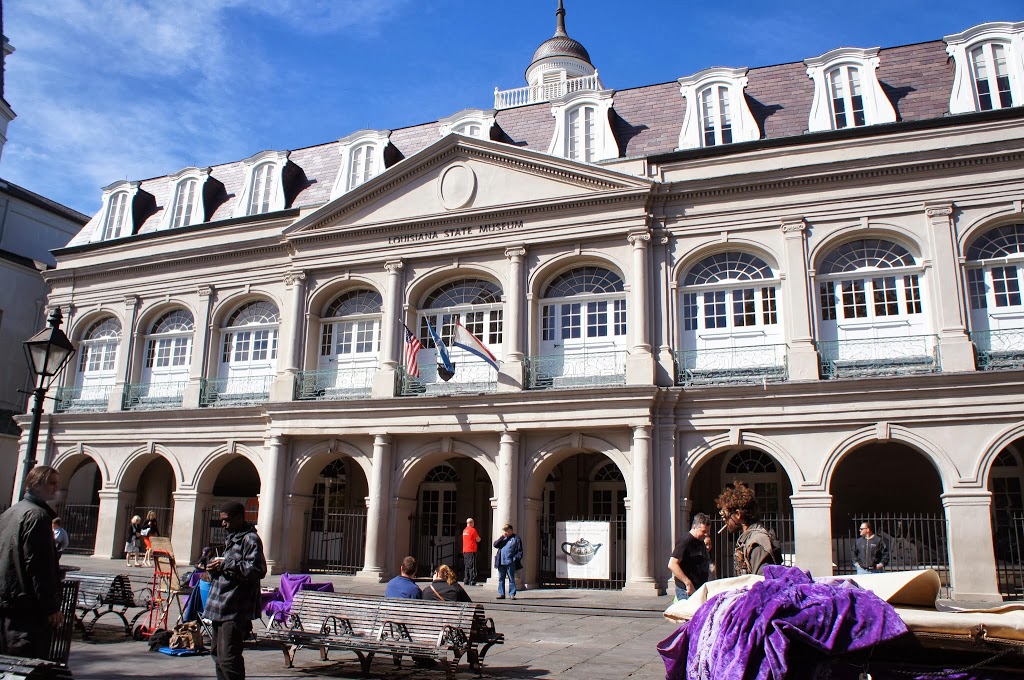
the Cabildo and its architectural twin, the Presbytere, buttress the St. Louis Cathedral on the northwestern edge of Jackson Square. fire destroyed the original structure in in the Great New Orleans Fire of 1788 and the present building went up between 1795 and 1799 to serve as the seat of Spanish governance for the territory. that role didn’t last long – the Louisiana Purchase transfer occurred in the Cabildo in 1803 and thereafter served as City Hall until 1853, as well as home to the territorial superior court (1803-1812). it also hosted notable visitors to the city, including the Marquis de Lafayette, who was granted use of the Sala Capitular during his stay. from 1868 to 1910 it served as State Supreme Court, where landmark cases such as Plessy v. Ferguson were adjudicated.

despite housing the Supreme Court, by the late 19th century the building had fallen into significant disrepair and was poised for demolition. artist William Woodward (known for impressionist paintings of the city and Gulf Coast) led a successful campaign to save and preserve the building. in 1908 ownership transferred to the Louisiana State Museum, which opened it to the public with historical exhibits shortly thereafter. it was added to the National Register of Historic Places in 1960 and underwent extensive restoration in the early 1990s following a fire in 1988 that destroyed the cupola and most of the third floor. it came through Katrina with relatively minor damage and served as temporary offices for Louisiana State Police as they patrolled the streets in the aftermath of the disaster. today the Friends of Cabildo run tours of the Vieux Carre, and the site hosts yoga in the second floor gallery that overlooks Jackson Square on Tuesdays, Thursdays, and Saturdays. (it sounded like fun … but we opted for a ride on the St. Charles streetcar, a long walk to Audubon Park, and run around the lake.)

beignets at Cafe du Monde

consumption of beignets sat squarely atop our list of tourist-musts for our New Orleans adventure. our very first stop on Friday morning, after a breezy but pleasant walk from our hotel next to the convention center into the French Quarter, was the Cafe du Monde – perhaps the best known source of beignets in the city.

situated diagonally across the street from Jackson Square, Cafe du Monde has operated since the 1860s, originally a part of the French Market. capitalizing on the popularity of their signature treat, at one time Cafe du Monde locations ranged all over Louisiana and as far away as Atlanta. today, there are just under a dozen locations around the greater New Orleans area. the French Market cafe is open 24 hours a day year round, with the exception of Christmas day and whenever hurricanes threaten enough to necessitate closure. the cafe closed on August 27, 2005, in advance of Katrina and, though the venue was only slightly damaged by the storm, the property owners took two months following the storm to refurbish the cafe while visitor numbers were down.

we arrived about 10:00 a.m. on a Friday to stand in line. while the line moved quickly, getting us under the awning in about 10 or 15 minutes, the same couldn’t be said for getting our tasty fried treats and chicory-flavored cafe au lait. when the beignets arrived, they proved mostly worth the wait, though by the end of my order they seemed to be losing a crucial degree of their warmth, if not their tasty, fried (and sugar-drenched) sweetness. not the best beignets I had on our trip, but still mighty tasty.

Bienville and the founding of New Orleans

this year, our Homecoming tradition took us for the first time to a city where none of us have ever lived, and two-thirds of us had never been: the Crescent City, the Big Easy, home of the cocktail, voodoo, jazz, and beignets — New Orleans.

we were up early the first morning to explore the city, heading first to the French Quarter the oldest and possibly most atmospheric of the cities sections. initially, I was taken aback by how little of the city’s early history I knew — first settled by the French, then taken over by the Spanish and returned to the French only to be sold to the fledgling United States. up from the Louisiana Purchase I have a vague understanding of how things operated, but I was delighted to discover a much more layered and rich history than I’d ever anticipated.

one of the first plaza statues we encountered was of Bienville, one of the founders of New Orleans and early governor of the French colony. born in Montreal, he was appointed to the position for the first time in 1701 and established several settlements, including a deep water port at Dauphine Island, what is now Mobile, Alabama, and ultimately New Orleans. the slight elevation made it far more practical than other sites along the flood-prone river and delta and was convenient to important trading positions. with permission from the company directors, he established New Orleans in 1718 and the heart of it — what is now known as the the Vieux Carre or French Quarter — was drawn up between 1720-21. the proposed grid pattern was largely overlooked by settlers initially, but when a hurricane flattened most of the existing structures in 1722, the new pattern went into effect, as we see it today. it became capital of the new colony, named for the Duc d’Orleans, in 1723.

the land had been inhabited for thousands of years by native peoples and, generally, the original inhabitants welcomed and aided early settlers, such as French trappers and traders traversing the Mississippi River. Bienville was known for his cordial relations with Native Americans, one of few early governors who could communicate without the use of an interpreter and, moreover, willing to aid local tribes against opposition tribes. many of the settlers were unsavory types and the governor complained frequently in his letters back to the central government. his relationship with administrators of the Company of the Indies, which controlled the colony, was fractious and resulted in him being recalled to France in 1725. he returned some 8 years later and severed as governor officially and focused on fortifying the settlement. all told, he served 30 years as governor over a 42 year period and retired to live in Paris for more than twenty years.

Underground Seattle

elevated indoor latrine

as many of you know, each year several of my college friends meet up for a mini-reunion weekend and, along with all the catching up, watching cheesy movies, and generally having a rollicking good time, we make it a point to visit someplace “odd” or go on a tour of someplace kitchy or uber-touristy. while the more fantastic-than-kitchy Chihuly exhibit would have sufficed, we’d already penciled in a trip beneath Seattle’s streets around Pioneer Square.

in the heart of the northwest woods, the original buildings of Seattle were made of timber. in June of 1889 a cabinetmaker knocked over flame and set his glue alight; when he tried to extinguish the fire with water, it simply spread. upon responding, the volunteer firefighters overtaxed the water pressure by using too many hoses and as a result some 31 square blocks of the fledgling town were destroyed. this devastation proved something of a boon for city planners, however, who had plans to improve living conditions in the city but lacked the means or mode to make it happen.

essentially, the relationship between the sewer system of early Seattle and tide waters into which the effluent flowed wasn’t terribly favorable for those who wished to keep sewage in sewers rather than all over the insides of residences and otherwise clean and sanitary buildings. while the tide was out, the plumbing worked just fine with the aid of gravity, taking the unwanted materials out to the low tide flats at the edge of Puget Sound; when the tide came in, however, it went rushing back up the pipes with unwanted effect. city planners wanted to level out the grade of the Denny Hill, bringing it down from something ridiculous (I swear our guide said 45 percent …) to something reasonable (along the lines of 10 or 12 percent) but the presence of buildings and business owners with businesses in said buildings who opposed the idea of closing down for the years a regrade would require made that challenging. even the fire and destruction of those buildings didn’t temper the protests of the business owners — the regrade was projected to take upwards of a decade and they had no intention of waiting that long to rebuild. so the two sides came to a compromise of sorts: the business owners would go ahead with their speedier plans and rebuild on the same level and in the existing grid pattern while the city would move forward with their regrade project and deal with the height disparity when the problem presented itself. between 1902 and 1911, water from Lake Union was pumped to the top of the hill where hydraulic mining techniques basically flushed the top of the hill down towards the bottom of the hill.

former underground marketplace

thus the Seattle Underground. even though the regrade project began in 1902, with retaining walls put up to protect sidewalks before filling and repaving the streets at the new level, the elevation of sidewalks didn’t occur for several years. instead, ladders stood at corners and people were obliged to climb up and down them to access businesses. according to our guide, this proved somewhat dangerous for the largely-male population of early-20th century Seattle; go out for a few rounds with mates, get confused about where (or whether) a ladder stood and end the evening with a tumble in to the underground. allegedly, several death certificates from this period have “involuntary suicide” down as the cause of death.

eventually, new sidewalks went up, supported by brick archways, but that didn’t eliminate shopping on the now-underground level — it just became an early indoor mall which was great in Seattle’s weather. to make the underground shopping experience more appealing, some areas of the new sidewalk included glass blocks that allowed light to filter to the subterranean level. initially, the glass was clear using the recently discovered technique of adding manganese to the process. now those same blocks appear amethyst in color due to the effects of time on manganese.

deciding under purple light
to walk through the dark bank vault

as business shifted to the upper levels, the lower were given over to less savory elements — including a huge rat infestation. underground markets had been held on wooden platforms built over hard packed dirt floors, allowing plenty of space and resources for vermin to thrive and potentially spread unwanted diseases, like the  bubonic plague. stemming from fear of a disease outbreak at an inopportune time, Seattle condemned the lower levels of buildings in 1907 though they remain, quite clearly, structurally sound and the routes the Tours take are cleaned up though in varying states of upkeep. it was incongruous to see some, situated beneath abandoned or disused buildings, filled with detritus and broken furniture while another, situated under a thriving department-type store, was swept up, well-lit and immaculate.

when our guide discovered that our group consisted entirely of people over the age of consent, she gave us a choice of how to make our way out of the second-to-last underground space: with the lights on like scardy-cats or like spelunking adventurers (my phrases) using naught but the light of our collective cell-phones to guide us. we opted for the latter and, just as we set off across the uneven footing she told us that the ghost of a failed bank robber was rumored to haunt the abandoned bank vault through which we were about to walk. in the dark. said alleged ghost did not attempt to snatch any of our party.

once back on the surface, it was back across the intersection of Yesler and First, under a wrought-iron pergola built in 1909 and knocked over twice by semis in the last eleven years, back underground for one last nugget of tawdry history and out through the conveniently-connected gift shop and “museum.” the area’s now recognized as an historic district and resides on the National Register of Historic Places.

oh! and once again, one of my favorite forms of social-media-based entertainment had an entry that inspired me to get working on a post I’d been mulling for some time! check out the “Subterranean Cities” episode of Stuff You Missed in History Class for more about some famous or infamous underground places. they don’t make any mention of the Victoria Arches in Manchester, though, which sound fascinating and a bit like Underground Seattle!

Starbucks in Seattle

one cannot accuse me of having an affinity for any kind of coffee, much less coffee from the most ubiquitous chain in the world … but that doesn’t mean we didn’t cross over to the other side of Pike Place to visit the original Starbucks location while we were in downtown Seattle back in October. somehow I’d gotten into my head that I’d visited the store while visiting Seattle back in 2007 but once I saw the line snaking out the door of the actual first Starbucks I realized my error. (well, really, the first one to open in 1971 was on Western Ave but relocated down the block to Pike Place in 1976 to make way for what is now Steinbruek Park.) in reality, I’d probably fallen for one of the other conveniently camouflaged locations also within a block of the Pike Place Market.

just got in line to order drinks…

in March of 1971, three guys opened the first location as a local bean roaster and retailer, inspired in part by the success of Alfred Peet (he of Peet’s Coffee) who also focused on selling high-quality beans and equipment. during their first year, they purchased green coffee beans from Peet’s to roast themselves before making connections to purchase directly from growers for themselves. in 1984, the original owners bought out Peet’s and, after deciding to focus their energy on that arm of their business, sold the Starbucks brand to Howard Schultz, who remains the chairman and CEO of the company. Schultz had been brought on in 1985 as marketing director and, after seeing coffee bars in Milan, tried to convince the original owners to incorporate such a concept into the Starbucks model. his efforts bore no fruit at the time and he left to open his own coffee shop (Il Giornale).

once under Schultz’s direction, the first coffee shop locations to open outside of Seattle were in Vancouver and Chicago. in 1986, before Schultz took over, there were 6 Starbucks locations; in 1989 there were 46 and they were roasting over 2 million pounds of coffee a year. in 1992 (the time of their IPO) there were 140 locations. four years later, they opened the first location outside of North America — in Tokyo; it took another 8 years before they expanded into Latin America (Mexico City). in 2003, Starbucks bought Seattle’s Best Coffee and an Italian outfit called Torrefazione Italia and expanded their stores to 6,400. now they have a a flabbergasting 20,366 locations in 61 countries. one wonders how that’s even possible (by buying out other chains, clearly)two weeks ago, they announced the purchase of Teavana — anyone want to take bets as to whether it will result in being able to procure tolerable brewed tea from your local Starbucks? (I’ll stick to my incredibly convenient and locally-owned CoffeeBytes.)

waiting (not in a line) for completed drinks

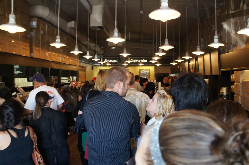
in any case, our trip to the (not-quite) original Starbucks delivered on our expectations. the line was out the door but the staff kept it moving along smoothly. all the died-in-the-wool Starbucks fans of our party picked out their purchases, many of which featured the original logo. it took about 10 minutes to get through the line to order, and maybe another 15 or 20 minutes longer waiting on drinks — and, according to our line attendant, it was a relatively slow day as there weren’t any cruise ships dumping their passengers into Pike Place. I will admit to taking satisfaction in that fact — I can’t imagine what the line would have been like on a truly busy day nor picture myself waiting patiently in that line.