one consequence of traveling with college friends who also studied political science is that when one visits a city with a Presidential Library, that Presidential Library comes up as a tour prospect. it also means you have much greater, more interesting context for the LBJ presidential years than what the library presents to you, which is a little exhilarating.
the library and museum are administered by the National Archives and include more than 45 million items, primarily from LBJ but also from close associates. the Library, situated adjacent to the LBJ School of Public Affairs on the University of Texas - Austin campus, was dedicated in 1971 with Johnson and Nixon in attendance. the core of the building is a remarkable four-story, glass-encased view of the archive’s holdings. quite a different presentation than the one I got to see first hand in the Wisconsin Historical Society archives - impressively illuminated and with each archival box featuring the Presidential Seal.
the top floor features is a 7/8th replica of the Oval Office as it appeared during Johnson’s presidency, including a cabinet with enough televisions installed to show all major networks simultaneously (you know, the 4 or 5 of them). in the corner of the building of that same floor, overlooking the football stadium, is Lady Bird Johnson’s office, preserved as she used it until her death in 2007.
the Point Sur Lighthouse stands atop a tall rock outcropping at the head of Point Sur, about 130 miles south of San Francisco on the Pacific Coast Highway. not surprisingly, the point has proved dangerous for vessels as long as they have traveled the Pacific coast of the U.S., with over a dozen notable wrecks - initially spurred in part by the increased traffic associated with the gold rush - between the 1890s and 1960s. beginning in 1874, following the wreck of the USS Ventura, the United States Lighthouse Service began campaigning for a light at Point Sur, arguing that of all the spots along the California coast still in need of safety measures, Point Sur was of the “greatest importance.” in conjunction with citizen petitions, USLS lobbying eventually prompted Congress to approve $50,000 for construction of a lighthouse in 1886, with an additional $50,000 allocated in 1887.
the resulting lighthouse and associated structures (which technically make Point Sur a lightstation) was built by a 25-man team over 1888 and was lit for the first time in August 1889, featuring a first-order Fresnel lens. life for the keeper, three assistants and their families was very isolated - moreso than Point Loma for sure - with the road to Monterrey often impassable and with resupplies coming in by boat every four months or so. for the most part, they had to be entirely self-sufficient.
the light and foghorn remain operational today, with both being updated to current technology by the Coast Guard in 1972 (the light was automated; the foghorn replaced with the impressive sounding “Super Tyfon Double Fog Signal” that can be heard up to 3 nautical miles distant). the last keeper left Point Sur in 1974. now, the Coast Guard services the station, but it is part of the Point Sur State Historic Park, run by the California Department of Parks and Recreation.
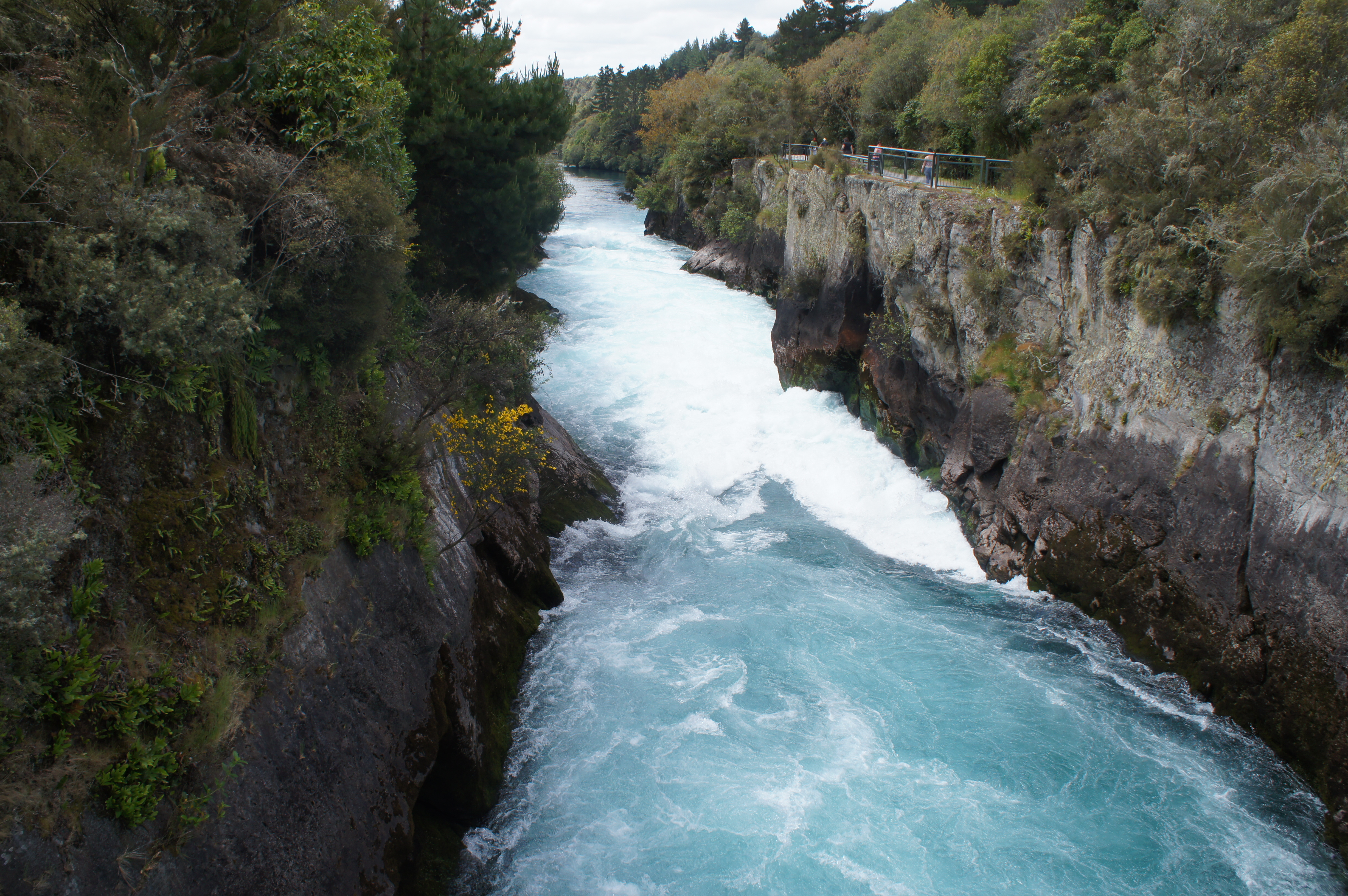
Waikato River is the longest river in New Zealand, running some 425 kilometers from Lake Taupo to the Tasman Sea just south of Auckland. the river is fed from as several streams on the side of Mount Ruapehu and Mangatoetoenui glacier on the mountainside, which are referred to as the Tongariro River prior to feeding into Lake Taupo. at the northeast side of the lake, the wide, meandering river wends its way past the town before funneling into a narrow canyon some 15 meters across, which is carved out of sediment laid down during the Oruanui eruption some 26,500 years ago. that eruption completely changed the landscape of the North Island, coating most of the land with tephra up to 200 meters deep, creating Lake Taupo, and changing the course of what is now the Waikato River from flowing northwest (towards the Pacific) to flowing northeast (towards the Tasman Sea). since the river settled on its northeasterly course, the canyon and falls have grown deeper and more forceful; some 200,000 liters of water tumble over the falls per second. the canyon is some 10 meters deep and the drop over the falls isn’t very dramatic, but the force of the water causes it to shoot out from the end of the canyon to the awe of thousands of visitors (including us!) each year.
spa culture in Rotorua received a big boost from the government in the late 19th and early 20th centuries, which built a series of structures for those hoping to benefit from “taking the cure” in one of the town’s many mineral baths. one of the prominent pools, known to the Maori as Te Pupunitanga, helped relieve the arthritis pain of a Catholic priest in 1878. while previously the site was known as a location of fierce battles and ambushes, it quickly became popular with spa visitors and was renamed Priest’s Pool in honor of Father Mahoney, with the government-constructed Pavillion Bath serving visitors. in 1901, the Duchess Bath was erected nearby to honor a visit by the Duke and Duchess of Cornwall and York - later George V and Queen Consort. the facilities were upgraded in the 1930s and maintained and operated by the government until the 1970s, when they were purchased by a private consortium and developed into the Polynesian Spa that stands on the site today.
nearby, the Malfroy Geyser, Rachel Pool and Blue Baths illustrate other ways enterprising Europeans capitalized on the geothermal activity of the area. in the late 1880s, a French-born engineer developed a system of artificial geysers using heat from a deep thermal pit, Oruawhata (said to be the final resting place of fierce Maori warriors to ensure they never fell into enemy hands), and a series of wooden valves that an operator could adjust to produce geysers reaching up to 12 meters high.
along with the Priest’s Pool, the Rachel Pool - known as Whangapipiro to the Maori - supplies the baths at what is now the Polynesian Spa. the pool is high in silica, a compound known for softening skin. it was (re)named after Sarah Rachel Russell - known as Madame Rachel - a cosmetician who promised everlasting youth through the use of her beauty line and who conned or blackmailed numerous members of the English elite during the mid-19th century.
the Blue Baths, also built by the government, date from the 1930s and provided a different type of bathing altogether. whereas the other baths focused on therapeutic aims, the Blue Baths aimed for a more festive, family-oriented swimming atmosphere. generations of local children learned to swim at the Blue Baths, something the other government pools could not provide. disuse led the Blue Baths to close in 1982 and they remained so until reopening in 1999 after extensive restoration.
as champions of Rotorua’s early spas hoped, the town has become an internationally recognized destination for “taking the cure” and enjoying the mineral waters that still bubble up from the geothermal waters - including the Rachel and Priest’s Pools.
the first national park established in New Zealand, Tongariro is also one of the oldest national parks in the world. the first parcel of land was set aside in 1887 under the protection of the paramount Maori chief in the area (Te Heuheu Tukino IV, also known as Horonuku) in order to protect sacred Maori land from being sold to European settlers. his family descended from the earliest settlers of Aotearoa (New Zealand), and identified with Ngatoroirangi, the man who navigated the vessel that brought the first people to the island and (according to myth) brought fire to Tongariro. once the land was under his protection, Horonuku gifted the land back to the state for preservation as a national park. while the initial parcel was considered too small to establish a proper national park (with the example of Yellowstone as comparison), subsequent government actions set aside larger and larger parcels of land for that purpose. in 1894, Parliament passed the Tongariro National Park Act, which comprised some 252 square kilometers (not all of which they had yet acquired). several updates to the Act over the 20th century brought the park to its current size encompassing nearly 800 square kilometers.
the three main peaks located in the park - Tongariro, Ngauruhoe, and Ruapehu - are tapu to the local Maori and development would have destroyed the mana of the sites. the Maori still have territorial rights over the mountains and when the Te Maari crater on Tongariro erupted in 2012, they declared a protective restriction (rahui) over the area to protect both the mana of the site and to ensure the safety of trampers moving through the area. because of its importance to Maori culture and its natural characteristics, the national park was designated a dual (cultural-natural) World Heritage Site by UNESCO in 1993, after previously receiving status for natural heritage in 1990.
although technically established in 1894, it took some decades before transportation caught up enough to bring significant numbers of people to visit the park. the first permanent park ranger began working in 1931, two years after the completion of Chateau Tongariro at the ski resort of Whakapapa. a road to Whakapapa was completed in the 1920s, making the journey much easier than the previous overland trek by horseback or foot. according to our lodge hosts, the park is far more popular for skiing during the winter than for tramping or biking in the summer.
until 2007 the track from Mangatepopo to Ketetahi was known as the “Tongariro Crossing.” however, the difficulty of the terrain and changeability of the weather found many trampers unprepared and the name was changed to include “Alpine” to better convey the reality of the track. we felt well-prepared setting out on the hike - both physically and in relation to gear - and I was still surprised by how much the climate changed on our hike - the limited visibility, bitter the wind and biting the precipitation through the South Crater, up the saddle beside the Red Crater, and past Blue Lake. not all trampers were as well prepared for the trek as we and the view from the trailhead might not prepare you for what was in store. moreover, in addition to the weather-related dangers were legitimate (though distant) volcanic risks. all three peaks in the park have been active in the last century with Te Maari in 2012 the most recent. when we stopped for lunch at the Ketetahi Hut, you could see active vents on the side of the mountain and the damage done by debris during the 2012 eruption. fortunately, that eruption occurred near midnight in August so the hut was not in use, but it remains closed to through-hikers due to its location in the active volcanic zone. in spite of the danger (volcanic and otherwise) some 80,000 people undertake the hike each year, with numbers growing.
it shouldn’t have come as a surprise to me, but New Zealand has a booming timber industry - has had for quite some time. prior to Maori arrival on the islands approximately 1,000 years ago, forests covered nearly the entire landmass. using fire, Maori cleared about 15 per cent of those forests prior to the arrival of European settlers in the 1770s. timber proved useful in ship repair - a constant necessity for vessels stopping on their way to or from distant ports. in the early 1800s, the population explosion of New South Wales further increased demand; and the Treaty of Waitangi in 1840, which paved the way for rapid European settlement in New Zealand, increased the pace of deforestation with thousands of acres being burned to clear farmland or clear cut to fuel the timber industry.
Looking southeast along Buffalo Beach at low tide
we saw evidence of the timber industry - past and present - nearly everywhere while traveling. one of the more interesting sites (which, to be fair, we didn’t observe ourselves) is the wreck of the HMS Buffalo at the bottom of Mercury Bay in Whitianga. the area around Whitianga was once thick with kauri forests, trees useful for their gum and resin, and the harbor on the northeast of the North Island somewhat sheltered from the Pacific Ocean useful for hauling them to distant destinations. ships came from as far away as Norway, Sweden, France, Italy, and the UK to collect some of the 500 million feet of kauri harvested in the region.
the Buffalo (originally named Hindostan) was built in Calcutta in 1813 as a food transport vessel and subsequently acquired by the Royal Navy for use (initially) as a storeship. over the years, the Buffalo also served as a quarantine vessel, convict ship (carrying 180 female convicts to Australia in 1833), transport for colonists bound for Australia, and finally a timber carrier.
Looking out over Mercury Bay from Buffalo Beach
in this last capacity, the Buffalo came to be anchored in Mercury Bay in July 1840. while today the harbor has moved into the mouth of the river (significantly more sheltered though perhaps impractical for vessels that size), in the 1800s the dock and pier extended out from what is know known as Buffalo Bay, near where our first hostel was located. on the 28th of July in 1840, a storm blew into the bay and parted the kauri-laden Buffalo from its anchoring cables. when it became clear that the ship could not be saved, the captain steered onto the beach and the crew abandoned ship. it sank and remains where it went down. in 1996 a team of maritime archaeologists and volunteers from Australia located and charted the site of the wreck and in 2009 the New Zealand Navy investigated the wreck using snorkels; much of the ship has broken up due to storms and spending more than 150 years underwater though the hull, reportedly, remains in good condition. at low tide on a day with exceptionally clear conditions you can see the wreck from above; the weather never got truly clear while we visited Whitianga and, more to the point, we didn’t get directly above the site, but neat to consider all the same!
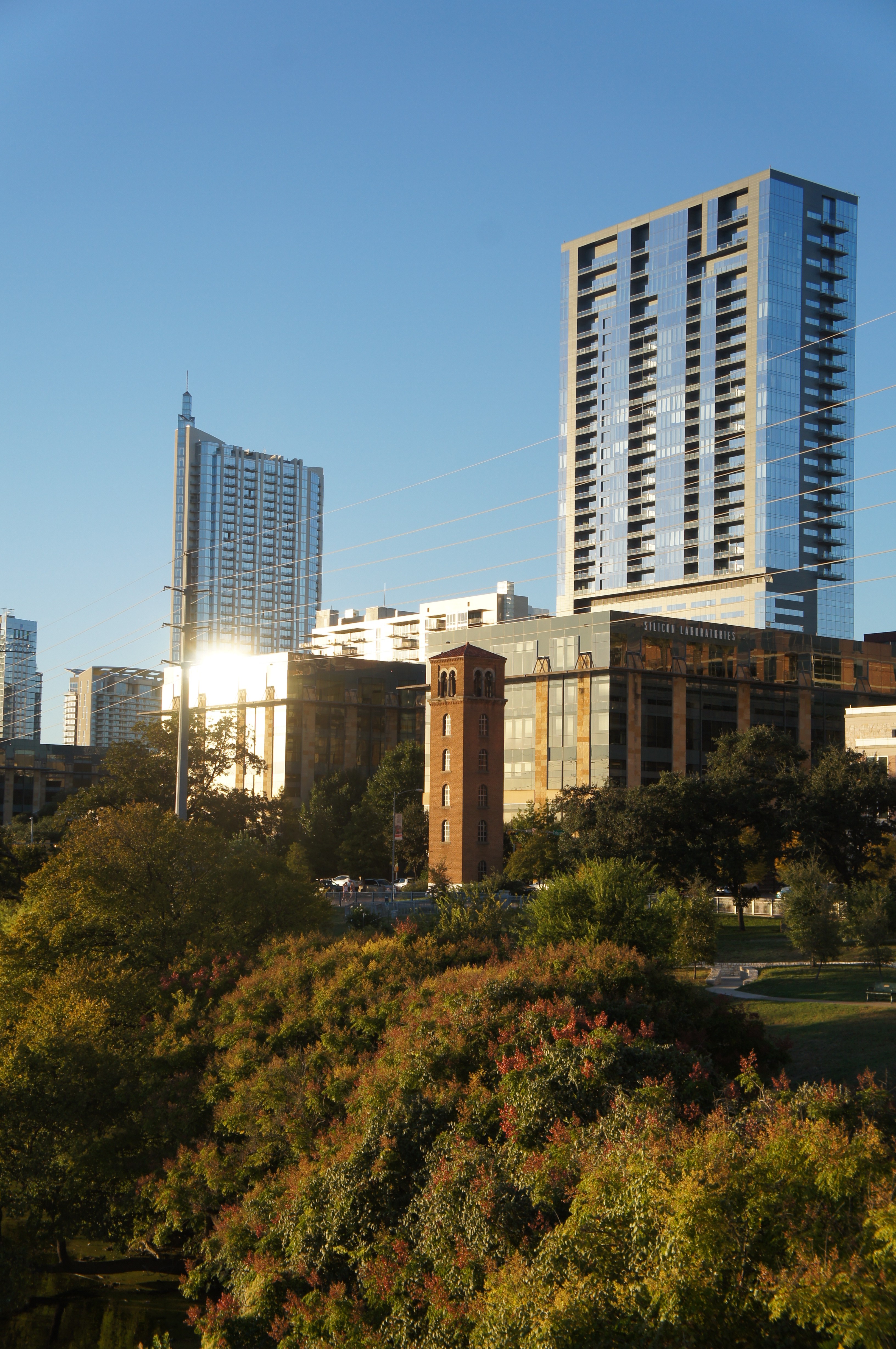
sucker that I am for buildings with interesting historical backgrounds, one of the sites I found most interesting on our amphibious tour of Austin was the Buford Tower on West Chavez Street. our driver, an admitted former firefighter, pointed out the building in passing - something the force used previously for training purposes - but I was curious to learn more.
Buford Tower against Austin skyline
built in 1930, it was used for practice for nearly five decades before being replaced by another structure elsewhere in town. it stood disused for several years until the widow of the man who designed the tower donated money to have it refurbished and to have the upper floors converted for use as a carillon tower. it’s name honors James Buford, a captain who drowned attempting to rescue a 15-year-old from flood waters in Shoal Creek. now, it’s an interesting, incongruous site against the modern structures of downtown Austin.
each year when my friends and I get together, we try to do quirky things in the city we visit, in addition to more traditionally touristy stuff. I’m not sure where on the spectrum visiting the Congress Avenue bat colony falls … quirky for sure, but also very popular! the colony consists of between 750,000 and a million and a half Mexican free-tailed bats; they summer in Austin and migrate to Mexico for the winter.
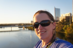
for all appearances, the bridge doesn’t seem terribly special; three lanes in each direction over Lady Bird Lake in a spot that has hosted a bridge since the early 1870s (a pontoon toll bridge). the City of Austin assumed complete responsibility over the (newer, iron) bridge in the late 1880s, which they were forced to repair several times over the subsequent two decades. by 1908, increase in traffic demanded the construction of a newer, wider bridge and a proposal for the current concrete span bridge were drawn up. at 910 feet it includes six spans which rise to 45 feet above ground; it opened on April 4, 1910.
the bats came to live under the bridge following refurbishment that occurred in 1980. there are fifteen crevices beneath the roadbed, each about 17 inches deep, which appealed to the bats and offered about 14,000 feet of potential habitat. the bats emerge from their roosts each dusk to search for food, swarming out towards the east for 10 or 20 minutes. tourists congregate on the bridge’s sidewalks, in the parking lot of the Austin-American Statesman, and on boats in Lady Bird Lake. we opted to stand on the sidewalk (near a family with two young boys calling out to the bats “hey, bats, come out so we can see you!”), but saw a fair few people out on water bikes, kayaks, stand-up paddleboards, paddle boats, canoes, and one paddling swan. we ended up waiting about an hour before the bats emerged, but in the interim the sunset off to the west provided a remarkable diversion .
Audubon Park, once a plantation, was used by both the Union and Confederate Armies during the Civil War, as well as staging ground for the Buffalo Soldiers following the war. named for the famed naturalist, the city purchased the park in 1870 with the intention of creating a park. little development of the park occurred in the first decade the city owned it, but it managed to host the World Cotton Centennial (a World’s Fair) in 1884. development began in earnest thereafter though nearly all of the Fair buildings came down in favor of others. structures went up and down throughout the 20th century - a miniature railway, swan boats, carousel, a viewing shelter on the banks of the Mississippi, a conservatory. several early features remain - a golf course from 1898 (converted to Par 3 executive course in 2002 and protested as desecrating the original design of the park), the zoo (which received development aid from the Works Progress Administration), and a rookery on Oschner Island, which hosts a wide array of birds (including herons, egrets, and cormorants) and apparently makes for some of the best birding in New Orleans.
during Katrina, a few of the park’s oak trees blew over, but the park escaped flooding and attendant problems because of its location on top of the River’s natural levee. following the storm, it served as a makeshift helicopter port and encampment for National Guard troops and relief workers.
we made use of Audubon Park for a morning run - once we finally got there, after walking from the end of the (construction-shortened) streetcar line. we had to share the 1.7 mile paved path (which was closed to vehicles in the 1980s) with a swarm of parents and children engaged in a charity run/walk of some kind. the costumes on some of the kids - and the gravel path to one side - mostly made up for the congestion. next time, I wager we’d try the longer dirt path that skirts the edge of the park!
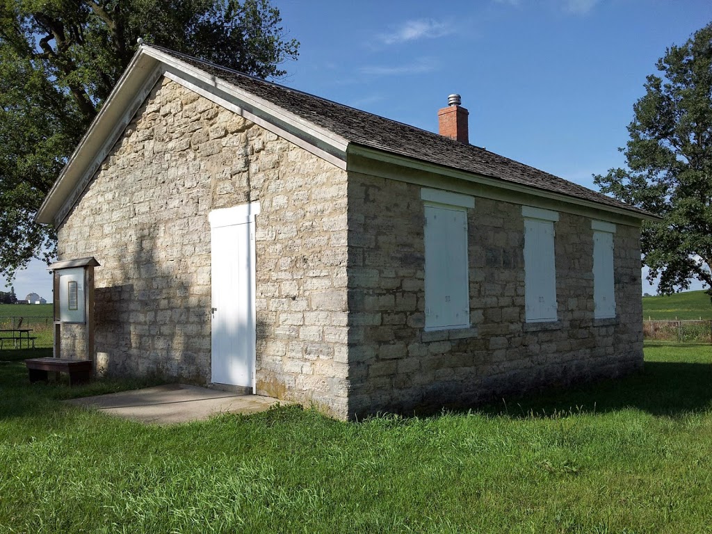
the Stone Academy sits on the side of the road north of Iowa City on the way to Dubuque - easy to miss but by far the most interesting roadside historic mark on that stretch of road. (all the others are just signs - a physical structure always beats just signs.) that route, highway 1, was the stagecoach route between burgeoning Iowa City and Dubuque, as well as part of the longer Montreal-Mexico trail. plenty of westward-moving settlers enjoyed putting down roots near a well-traveled road. at the time, Native Americans had not yet been shunted out of eastern Iowa and still lived in camps along the stagecoach route and within site of the school building. built in 1842, before Iowa became a state, the school remained in operation until 1953. the stones for the building were quarried on the east bank of the Cedar River, ferried, and hauled two miles to construct the schoolhouse. students attending the school came from nearby farms and homesteads and varied widely in age; some young men, otherwise considered “too old” for school, would attend during the winter as it provided a diversion between harvest and planting. today, it’s shuttered but maintained, well off main routes of travel - unless you’re going from Dubuque to Iowa City.


 Waikato River is the longest river in New Zealand, running some 425 kilometers from Lake Taupo to the Tasman Sea just south of Auckland. the river is fed from as several streams on the side of Mount Ruapehu and Mangatoetoenui glacier on the mountainside, which are referred to as the Tongariro River prior to feeding into Lake Taupo. at the northeast side of the lake, the wide, meandering river wends its way past the town before funneling into a narrow canyon some 15 meters across, which is carved out of sediment laid down during the Oruanui eruption some 26,500 years ago. that eruption completely changed the landscape of the North Island, coating most of the land with tephra up to 200 meters deep, creating Lake Taupo, and changing the course of what is now the Waikato River from flowing northwest (towards the Pacific) to flowing northeast (towards the Tasman Sea). since the river settled on its northeasterly course, the canyon and falls have grown deeper and more forceful; some 200,000 liters of water tumble over the falls per second. the canyon is some 10 meters deep and the drop over the falls isn’t very dramatic, but the force of the water causes it to shoot out from the end of the canyon to the awe of thousands of visitors (including us!) each year.


 Audubon Park, once a plantation, was used by both the Union and Confederate Armies during the Civil War, as well as staging ground for the Buffalo Soldiers following the war. named for the famed naturalist, the city purchased the park in 1870 with the intention of creating a park. little development of the park occurred in the first decade the city owned it, but it managed to host the World Cotton Centennial (a World’s Fair) in 1884. development began in earnest thereafter though nearly all of the Fair buildings came down in favor of others. structures went up and down throughout the 20th century - a miniature railway, swan boats, carousel, a viewing shelter on the banks of the Mississippi, a conservatory. several early features remain - a golf course from 1898 (converted to Par 3 executive course in 2002 and protested as desecrating the original design of the park), the zoo (which received development aid from the Works Progress Administration), and a rookery on Oschner Island, which hosts a wide array of birds (including herons, egrets, and cormorants) and apparently makes for some of the best birding in New Orleans.