the walled city of Pamplona

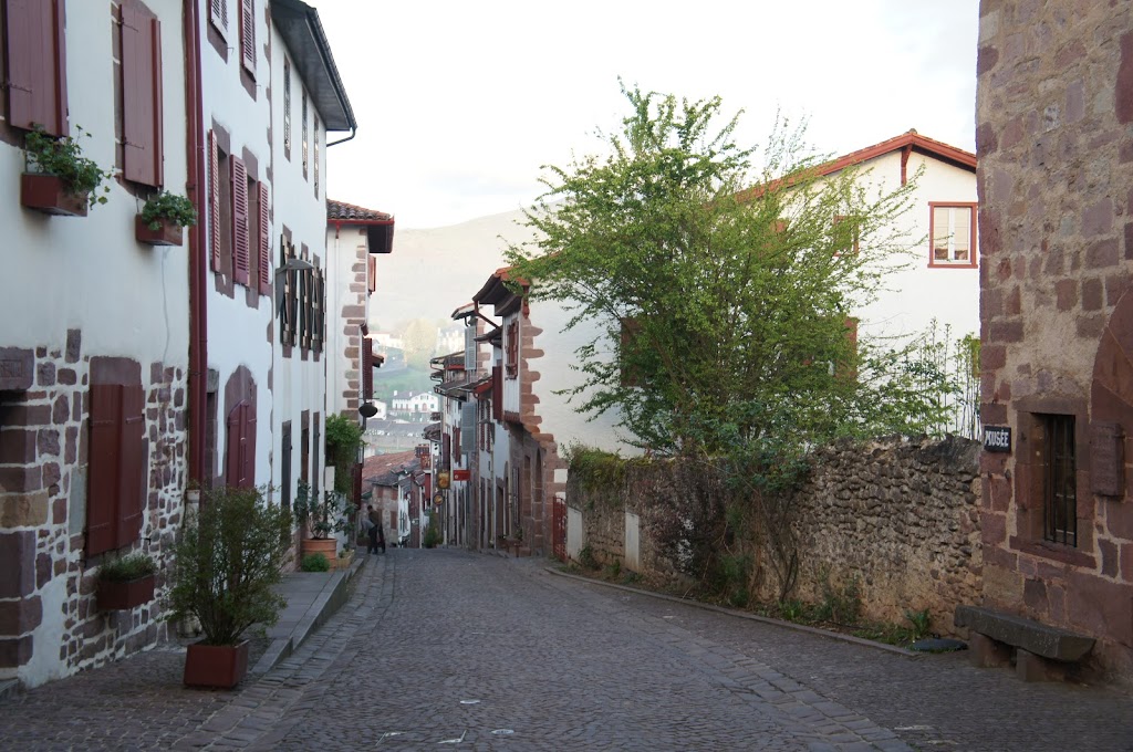
of all the medium-to-large sized cities we walked through, nothing compared with the approach to Pamplona. it was damp during the last several kilometers, but not enough to properly be called “rain.” unlike later cities (looking at you, Burgos) the suburban sprawl to the east of Pamplona is limited and relatively picturesque. after crossing over the river, the walls of the city loom up suddenly behind the trees and demand a moment to take them in.

in 75-74 BCE, Pompey set up camp on the site of what is now Pamplona, establishing the village that over centuries grew into the city we see today. it later became the primary city of the Vascones (Basques), called Iruña. the intervening centuries saw the city controlled by all manner of rulers — Visigoths, Basques, Muslims. for a period after the Muslim conquest of Pamplona in 715, things remained stable as the Basques near the Pyrenees seemed disinterested in repulsing or ousting the Moorish troops and the city may have even flourished. as the 8th century progressed, however, control over Pamplona vacillated between Moorish and Frankish control with neither side able to gain satisfactory control. in 778 as he fled back towards the Pyrenees, Charlemagne is said to have destroyed the walls of the city (if not the entire city) in a bid, as mentioned, to prevent his enemies from using it in the future. this went counter to agreements he’d made not to attack the city walls and may have spurred Basque rebels into the ambush and battle that destroyed his rearguard in Roncevaux Pass.

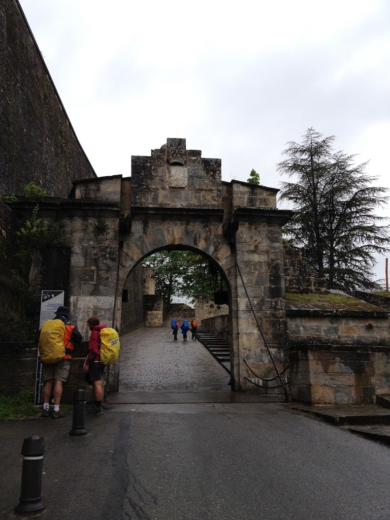
city prospects revived again in the 11th century, helped by the flow of peregrinos along the Camino. the city enlarged with two additional boroughs in the 12th century — meaning three distinct (and often conflicting) towns existed within the city’s fortress walls. the king unified the boroughs into one city in 1423, which remained the capital of the autonomous kingdom of Navarra after its annexation to Spain in 1512. Castilian conquest a year later and advancements in military technology prompted enhancements to the city defenses, including the construction of a massive star for on the city’s south and fortification of the city walls. the walls we passed through date from the late 16th to 18th centuries. 


because of the city’s military importance, the walls restricted growth — expansion had to go up rather than out, resulting in tall buildings, warren-like streets, and a dearth of open spaces and courtyards. by the end of the 19th century, housing density reached a critical limit and modifications to the star fort allowed an expansion by six city blocks. woo! three decades later, however, the advent of the First World War and its attendant military advancements rendered Pamplona’s existing defenses useless and in short order the southern wall was demolished to allow for rapid urbanization and expansion from the 1920s to the 1950s and into the present day.


Pamplona is the home to the University of Navarra (ranked as the best private university in Spain and the campus of which we walked through on our way out of the city) as well as the infamous Opus Dei, which operates the University. city industry is diversified with the automotive industry making up the largest part. renewable energies are also increasing their presence in the economic sector — which is evinced by the line of wind turbines dotting the ridge to the west of the city (about which more in my next post). nearby Sarriguren is home to the National Centre for Renewable Energies.


and of course there’s the (in)famous running of the bulls every year in July during the Festival of San Fermín. can’t say I’m sad we missed it — there’s no way we would have gotten a room at our awesome hotel and would have had to contend with thousands of people while we made our way wearily out of town just as they’re releasing the bulls.

St. Jean-Pied-de-Port: a beginning with history

looking west down the Rue de la Citadelle from the Porte St-Jacques

the peregrinos that started coming from “beyond the Pyrenees” in the 12th century were overwhelmingly French, in part because of protection provided by the Kingdom of France. enterprising individuals followed the peregrinos from France and set up hospitals, hospices, inns, and other businesses catering to the needs of those trekking to Santiago. four separate routes originated in France –including the route we followed from St. Jean-Pied-de-Port, over the foothills and into Roncesvalles — and converged on Puente la Reina beyond Pamplona.


for those walking “the whole way” St. Jean-Pied-de-Port is the most popular point of departure and head of the Camino Frances. plenty of people start in Roncesvalles or Pamplona instead, avoiding the arduous 1300m ascent (and descent) but coming from St. Jean affords a certain degree of pride and bragging rights. besides, after a climb that challenging and long when your body isn’t sure yet what you’ve gotten into you are prepared for anything over the next 775 or so kilometers.

St. Jean-Pied-de-Port (St. Jean at the foot of the mountain pass), or Donibane Garazi in Euskara, lies about 8km over the French border straddling the Nive River. the area was settled before the 11th century and, after the destruction of the original settlement in 1127, the King of Navarre had the town reestablished in its present location to fortify the northern defenses of his territory. over the centuries, the location proved strategically important — as a stopping point on the Camino, a trade center, on the route through the mountain pass to Roncesvalles, a military outpost and garrison. the King built a fortress on a hill to make it easier to defend the pass and the town became a key urban center in northern Navarre and important defense against attempts to advance on Pamplona.

in the early 16th century, the unification of Aragon and Castille (through the marriage of Ferdinand & Isabella) resulted in the defeat of the Kingdom of Navarre and, ultimately, closer ties with France in an effort to repel their mutual Spanish enemy. in 1620, Louis XIII (descended from Kings of Navarre) unified the Kingdoms of Navarre and France. as before, St. Jean proved a vital defensive component in the bitter rivalry between antagonistic kingdoms. advances in weapons technology resulted in a more “modern” fort, roughly similar to what exists today. over more than a century the structure was modified, fortified, and improved upon. the town suffered throughout the Revolutionary period and Napoleonic wars, serving as the center of a massive military encampment from which numerous attacks were launched on Spanish cities over the mountains. the town hosted a military garrison until 1920.

the main cobbled road through town retains many of the same features established in the middle ages. the Porte St-Jacques stands on the eastern end of the old town, while the Porte d’Espagne stands at the other. our hotel was one block over, outside the historic center in an area built up in the mid-to-late 19th century, spurred by the Enlightenment and construction of a train station in 1898. houses on along the rue de la Citadelle have changed little and some still bear markings from construction or inscriptions added centuries ago.

because we arrived in St Jean late on Saturday evening, we had to wait until the Pilgrim Office in the rue de la Citadelle opened so that we might obtain our first sellos — stamps verifying we’d walked from St. Jean and  were therefore entitled, as peregrinos, to stay in the aulbergue in Roncevalles. as we waited, we walked up the hill to the Port St-Jacques and took a peek at the Citadelle, duly impressed with the centuries of history surrounding us and knowing these streets and walls weren’t the oldest sights we’d encounter on our journey.

Fort Jefferson

approaching Fort Jefferson on the Yahkee Freedom II

situated on Garden Key, Fort Jefferson is the largest masonry structure in the Western hemisphere and served as a military prison and outpost during the 19th century. located 70 miles west of Key West, it sits at the tail end of the archipelago and, really, ought not to support human life. the collection of islands originally got their name from the sea turtles that nested there; in short order map-makers added the “dry” designation to warn sailors of the lack of potable water. upon scouting the keys for possible military installations, Commodore David Porter reported that the Dry Tortugas consisted of sand islands barely above the surface of the ocean with scarcely enough land to permit construction of a fort, much less support one without sinking below the waves.
the moat from the atop the walls of the Fort

Porter’s observations not withstanding, the government determined the islands useful to house, at the very least, a lighthouse. three years after Porter’s initial observations, a successor stressed the strategic importance of the islands in the Gulf shipping channel, prompting movement on a permanent, fortified outpost to defend U.S. interests.

harbor light atop the Fort wall

work on the structure began in 1846 and never finished, though construction (by slaves and prisoners) continued for 30 years. the original lighthouse stood within the fort walls but, after it suffering damage during a hurricane, was relocated to Loggerhead Key some 2.5 miles distant. the design originally called for a three-tiered, six sided brick structure; the sides met at corner bastions, which allowed some of the 410 guns to fire along the walls at ships crazy enough to come within range of the cannons. most of the armory and artillery improvements went unused. my favorite one, which I’m almost sad never got used, was a building designed to heat up cannon balls so that, when fired at enemy ships, the shot would start the wood on fire, burning and sinking the ship simultaneously. as construction progressed, however, concerns arose that further weight would cause the structure to sink (further) and result in further damage to the cisterns and undermine stability of the fort.

cells were left open to the elements, to prevent added weight

at its peak, some 2,000 people lived at Fort Jefferson, including military personnel and (occasionally) their families, prisoners, and (prior to the Civil War) slaves. it served as a harbor for war ships defending Gulf ports, such as Pensacola, New Orleans, and Mobile, general deterrent for anyone considering an attack against U.S. merchant ships, and evocative symbol of America’s intentions towards any potential aggressors (we’re lookin’ at you, Mexico!).

 it remained under Union control throughout the Civil War, which resulted in some tensions with Key West, which, naturally, fell under Confederate control. Union ships used Fort Jefferson as a port in the blockade of Southern ports and it became a military prison, primarily for Union deserters, but also for special civilian prisoners, including Dr. Samuel Mudd. following his assistance during a yellow fever outbreak in 1867, President Andrew Jackson pardoned and released Mudd and, in 1874, the Fort ceased to function as a military prison.

balls placed at the far end heated up as they came down the chute

while Fort Jefferson was more or less abandoned by the Army in 1874, it did prove useful in other ways over the next half-century. the Navy used it as a coal refueling station for warships (we got to snorkel around the refueling dock pylons — lots of very cool fish); it served as a quarantine station for a time; the USS Maine sailed for Havana from Fort Jefferson, and other warships followed during the Spanish-American war; a wireless station operated from it around the turn of the 20th century; it briefly served as a seaplane base during the First World War.

the Fort contains 2,000 archways like these

beginning in the 1930s, activity in the Dry Tortugas gave over to biological research and historic preservation — the Carnegie Institute operated a marine biological institute on Loggerhead Key beginning in 1930 and, following a visit in 1935, President Franklin D. Roosevelt designated Fort Jefferson a National Historic Landmark. Fort Jefferson was placed on the National Register of Historic Places in 1970, and the Dry Tortugas became a National Park 1992.

recent boat used by Cuban refugees — Fort Jefferson counts as American soil for refuge purposes